We had chosen Expedition India as a race to do this year because we thought it would provide something different both as a race and an overall experience – and it delivered big time. Angus Rodwell joined us for the first time this race and it was great to have a strong, dependable guy on board for a race full of unknowns.
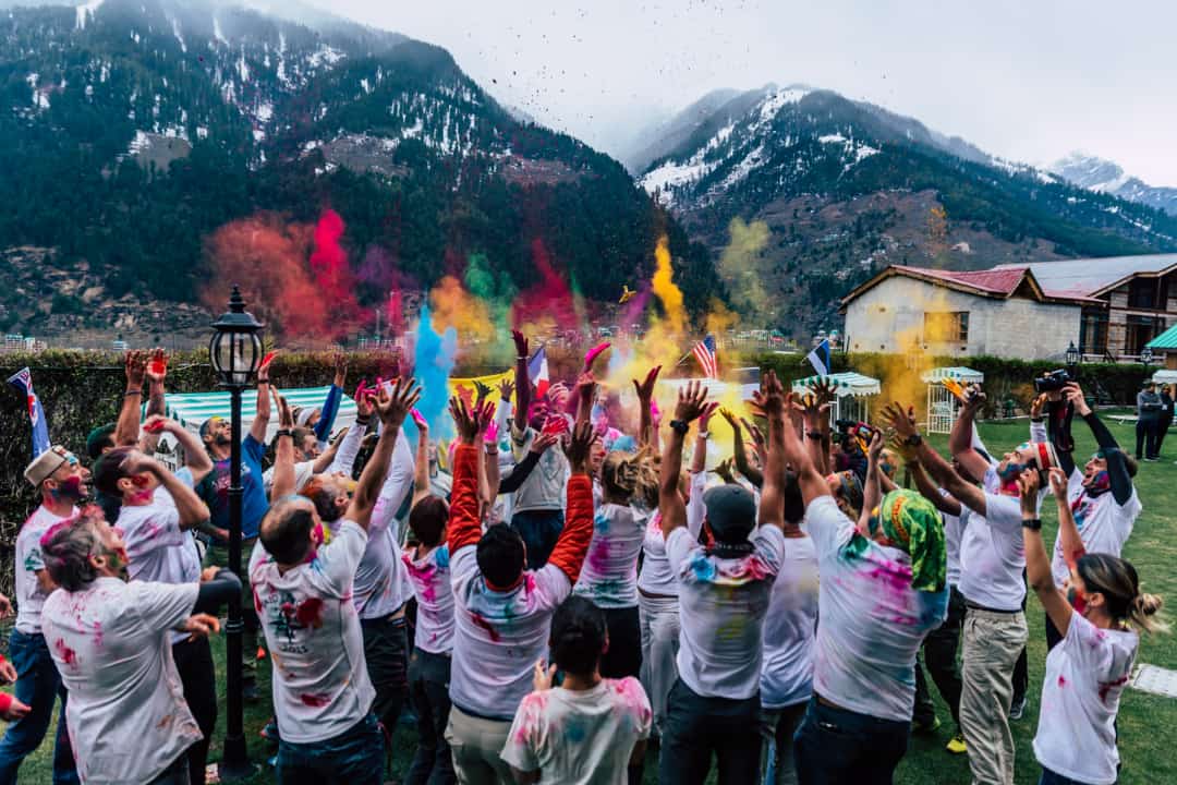
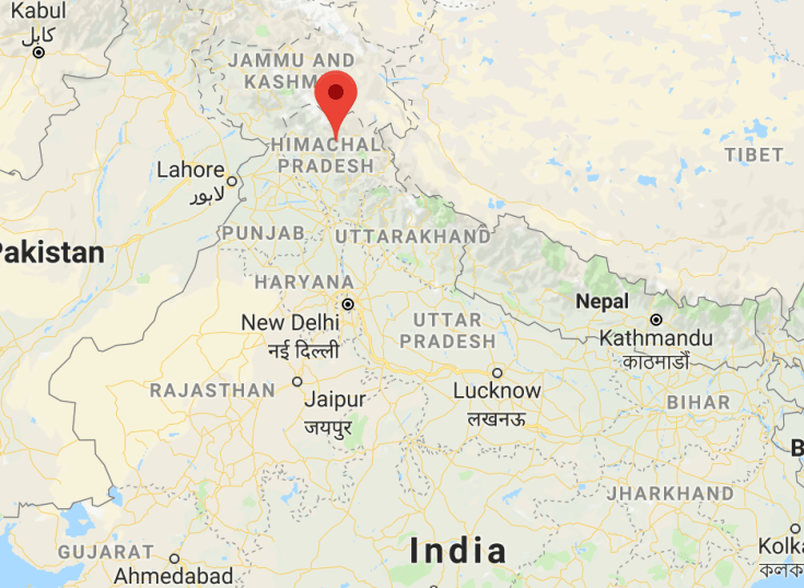
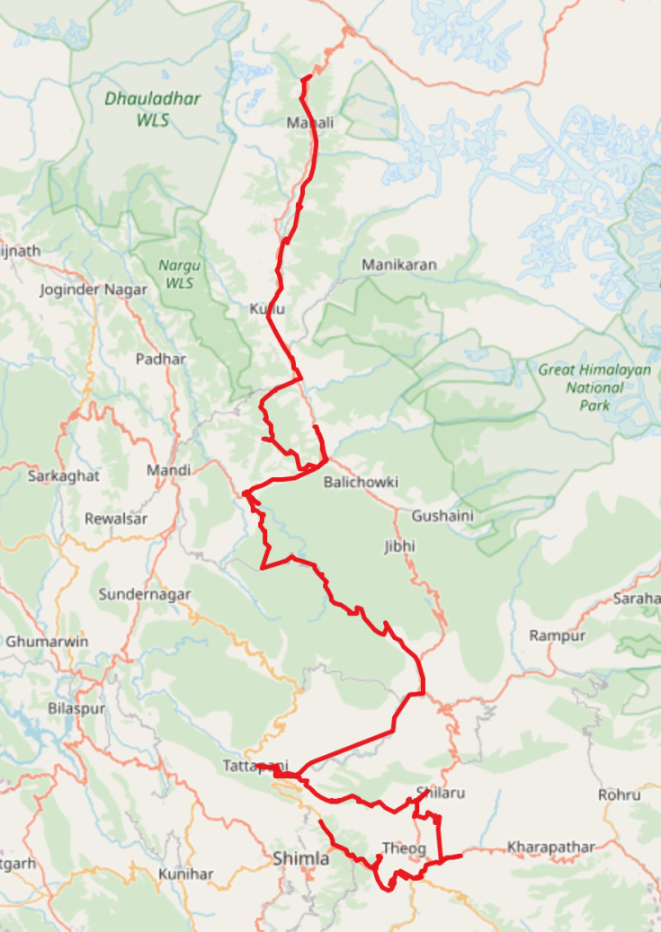
The race was to be held in the mountainous Himachal Pradesh region in northern India, starting at the town of Manali and finishing in the mountain top town of Shimla. Getting there was an adventure in itself with the usual flights and an epic 16 hour bus ride from Delhi on roads which defied belief at times (especially when you are in a 40 foot bus). We got to Delhi a few days early and had some excellent down time seeing the sights of there and the Taj Mahal. This gave us a little taste of the cultural experience this race was going to provide with India’s population density being very high. Even shopping was an adventure with us having a “breath taking” Tuk Tuk ride back to the event hotel when our two drivers decided a little race was in order! We were also treated to our own little Holy festival on arrival in Manali (the celebration of starting Spring).
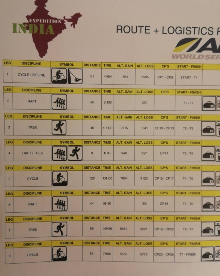
Registration and competency formalities were very well organised and efficiently finished ahead of schedule (very unusual for pretty much every thing for this race). We were all itching to get hold of maps, but they were to be released as we went, with only stage 1 provided to us before the race, and this was to have a style of maps unique to this stage (no contours on the 1:50K maps in this area – apparently for security reasons or something). The race logistics planner looked seriously daunting, but post race we think the elevation numbers were in feet not metres, which make it slightly more palatable!
It was apparent that a mid-race dark zone for the long rafting leg would be critical for the race. Our estimates suggested that not many teams would get on this before dark and that a long night’s rest could be expected (provided nothing went wrong!).
Leg 1: 40km MTB
It was a pretty chilly start to the race with a delay of an hour or so whilst the organisers cleared snow and ice from the road. The areas had received a large amount of late snow this year which necessitated changes to the course coming into the race and again on the morning of race start (the most recent snow was only a day ago). This leg was largely a downhill ride through villages and rural areas on back roads, with a stop at a massive zip line ride along the way. We started well and enjoyed the craziness of riding in amongst the local traffic (ie cars, bikes, cows, dogs, people etc). It was a bit of a race to get to the zip line to avoid queuing and we were in pretty good shape until a minor mechanical put us back in the pack and got to the zip line about 6th which meant about a 15 minute wait. Josh and Hugh did the zip line, which was quite good fun, but not built for heavier riders with Hugh needing to do a bit of pulling to get the last few m of each line completed.
The rest of the ride included a little bit of tricky navigation with the maps not being very clear and we got through without any major dramas only to arrive at the TA ahead of all our gear. This was to be a common problem at this race with the logistics transport being held up in traffic much more than organisers expected (partly due to an unusual number of landslides).
Leg 2: 26km Raft
After about a 20 minute wait our gear arrived and we were off on the first rafting leg of the race. This had many unexpected elements. Unfortunately rivers in this area double as garbage dumps so the water quality was quite scary and we took care to keep our mouths shut as much as possible. There were some pretty rough sections which made for good fun, but our guide had little experience with people wanting to race and did not know the river very well. We ended the leg a little frustrated after getting hung out on many rocks we should have missed and having our guide stop to check where he was a number of times. We did not have maps as they had not made it to the TA in time. Still we finished the leg in pretty good shape about 20mins behind the leaders.
Leg 3 & 4: 40km Trek, 8km “Raft”
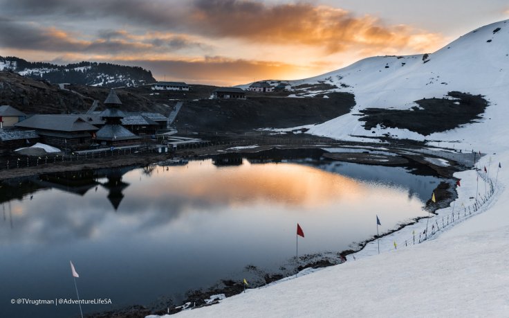
We got our maps as we transitioned and had our first exposure to how “busy” they were with lots of towns and contours! There were miles of faintly marked walking trails, but apparently many more existed on the ground around villages and farms. This first leg had a couple of route options with the main one being a choice to follow the high (= snow covered) ridgeline and going down and up a valley which was likely to have some tracks used by local farmers. After a little hiccup at the second CP, which did not quite match the map we were on our way up the climb as darkness fell. We had a few swings and round abouts with our trail picking with a couple of winning decisions offset by some not so good choices that left us scrambling up a river back to the trail we wanted. Most teams apparently suffered similar fates in the dark. We found the going on the ridge excellent initially until the snow became thicker as we got above 2500m. Here we made the decision to drop over the ridge and seek some paths through the valley and this proved to be a good one when we found a nice trail traversing its way to the target saddle and not too much snow to deal with. From there we got directions from some campers to the next CP at Prashant Lake, but we struggled to match the map to the roads and lost a little time before being sure we were on the right track. The temple at the lake was stunning even in the moonlight and photos in the daylight we saw after the race confirmed this.
 From here it looked straight forward on the map, but it was not to be. As we headed up to the ridge to get down to the dam for the short flat water rafting leg we came across an unmarked road, whilst this made going good down the steep hill, it also made it tricky to keep track of where we were with countless switchbacks and changes in direction. We were with Estonia Ace and Bend Racing and, as can happen when you are with a group, lost concentration and began compounding of small errors into a massive mistake:
- following the unmarked road we were not sure which valley it ended up in
- we wrongly assumed we knew our location when the shape of the road matched a different part of the map (not realising there was an almost exact match of that part of the road further east)
- We came out to the bottom and went to the nearest dam not realising this was a second dam 15km east of the one we were meant to be paddling (and had trimmed the maps so did not see it on the maps)
- the second dam was remarkably similar in shape to the correct one, and we assumed the maps were old so we explained away the differences in roads etc
- We asked for directions and some locals seemed to think the town we wanted was upstream (when it was down stream).
And so it went on but the summary is we walked an extra 30km to the wrong place and back again, consuming a solid 6 hrs of time we had hoped might be rest at the upcoming dark zone. To top it all off when we got to the TA we were advised the rafting was cancelled and we had another 15km road bash to the bike TA. We had recovered from our mental anguish by this time (Hugh in particular) and focussed on getting as much progress as possible to maximise our sleep before the dark zone.
Leg 5 – 120km MTB
We got the next set of maps and plotted out the route. On the maps it looked straight forward, but there was plenty of climbing (up to 2700m which was well into snow territory) and there were additional roads marked on the map so we could never be quite sure what was in store. We made good progress and caught two teams as we topped the first climb at sunset. We had a big decent then a long traversing climb before hitting what we assume were forestry roads for the second major climb.
We decided to stop at a small hotel for a few hours sleep just before midnight, the plan being to get a good rest in beds so we would be as fresh as possible when we arrived at the raft TA the next morning. This plan worked well, although the hotel owner was really confused as to why we only wanted the room for three hours and the we were all happy to bunk in to the one room (which had a massive bed). We slept like logs and were back on the road feeling good by 1am. The next section was a little confusing with more hairpins on the ground than on the map and the extra roads not quite matching what we saw on the ground. We followed the main track and this took us where we needed to go. Many of the other teams were tempted by a turn which turned into a “shortcut” hike a bike so we were petty pleased with our decision making here. We had a few “real or not real” questions when we came across diggers clearing the road under lights at 4am, but they were indeed real and sorting a fresh landslip before the traffic started in the morning. It never stops even on backroads in India!
Next was a massive decent that just went forever (40km and about 2000m down) and was good fun in the dark without much traffic. We ended up getting to the paddle about an hour ahead of expectations given us plenty of time to transition before the dark zone finished. Not much sleep but we were back with the bunch!
Leg 6 – 44km raft (last 9km flat water)
Things did not go quite as expected in this TA, but in a good way. First our bike boxes and gear bags were not all there so we could not properly transition. Second the rafts and guides were late so it seemed the start would also be delayed for everyone. We took the chance to get more sleep and got a couple more hours so that was a bonus and got on the water by about 9.30am, along with 9 other teams starting about a minute apart.
 We were also lucky that they released additional water into the river that morning which made the rapids bigger and faster. The guides were much better this time and Gus had done a great job of interviewing and finding a super cool guide. Not only was he good fun, steered the boat on good lines and laughed at our jokes, but he was the strongest man in the world (or so it seemed to us). On the short portage he carried half the boat by himself (which those that have carried a full size river raft will realise is no mean feat) and then proceeded to drag and throw the raft down the mini cliff we had to get down to get back in the water, whilst all we could do was scramble out of the way of the raft as it came flying down the rock slope.


Back on the water we found good lines and enjoyed the remaining rapids before the water slowed and the 9km grind to the end commenced (the guides got off at this point). We had passed Bend Racing on the side with a team member urgently extracting themselves from their drysuit and were later to find out that illness was striking a number of teams.
Leg 7 – 60km Trek
At this TA we received maps for the last two legs and we set of in good shape after a slightly slow transition due to battling other teams plotting CPs and markups on to the maps. It is interesting to do this when you are both tired and rushed in the latter part of the race and we ended up taking the time to ensure we had it right. After a few km of road bashing we started what would end up being a 2200m climb following rivers up to a Temple at 2900m.


Importantly the trail/route had been hand marked on the map. The first part was easy enough to follow, but when we got up to the third CP we did not find it where we expected it to be. After assuring ourselves we were in the right place we pressed on, but after a few km of scrambling on an ever less obvious track and river bed, we began to have doubts. We had not seen any other teams for a while ahead or behind, and were not sure if the additional trail marked on the map was meant to be walking path or a passable route.
In the end we decided to go back to confirm we had not started at the wrong place. This would be costly, but we figured it would be better than heading up the wrong gully in the dark. We found a couple of other teams looking for the CP and heading in the same general direction, but given our experience with the disappearing path we decided to have a sleep till light to make sure (about 6 hours).
This started out very well as we found a pile of hay and tarp the covered into a lovely dry bed for four and we (mostly) slept soundly, only woken by the US team Rootstock, who were also wandering around looking for the CP. We let them go and went back to sleep.
We woke to a nicer morning but unfortunately also to Bern emptying her stomach contents onto our bed. Not great – she also made a few urgent toilet stops before we got going! At this point were were well out of race mode and it was just about surviving to the finish. Gus carried Bern’s pack and Josh put her on tow and we headed up the climb once again. In the light the route was not only obvious, but was exactly the same as were we had been the night before. Frustrating! The trail faded in and out a bit and was hard to follow, but it did continue so our doubts from the night before were not well founded.
We pressed on making good progress (between regular stops for Bern). The climb was steep, beautiful, relatively free of litter and relentless. After 5hrs or so we crested the top to see the temple just up ahead along the main path that came in from the other direction. This was a race highlight as the day was super clear and the horizon was packed with Himalayan peaks (which unfortunately do not show up on the photos). We spent some time soaking it up and eating breakfast at the summit.
There was still 20+ km of trek remaining where we had a choice between following a high ridgeline or going down and up through the valley. From where we were the ridge looked like hard work so we headed off into the valley. It did not take long to figure out the the roads were way longer than the direct route and once we decided to branch off and follow the unmarked walking paths between the villages we started to make good progress. We enjoyed lot of encouragement and amazed stares from the local farming population, who regarded us like aliens!
It was going up the final climb to the TA that things went a little astray, not because of navigation or illness this time, but because whilst Hugh was facing off a couple of aggressive farm dogs, a third nipped him on the calf from behind. Dog bites are not something you want to have in India, but we figured there was not too long to go so cleaned the wound up and pressed on (the saga of post race rabies treatment would end up taking a fair bit of time for Hugh).
Leg 8 – 85km MTB
We were entering our fourth night at this point and although we had had plenty of sleep, there was still a lot of fatigue coming into play so we were careful to plot a sensible route trying to stick to what we thought were major roads rather than walking tracks. The leg was essentially a huge decent down to and following a river followed by an equally huge ascent to the finish resort which was back up at about 2200m. We had one minor hiccup were we headed up the wrong road for a couple of km, but aside from that it went smoothly, but VERY slowly. We were not able to climb at much more than 6km per hour and with 20km or so of solid climbing this meant it took a while to break the back of the hills. We were rewarded with a lovely traverse around the last set of peaks which came with spectacular views of the Himalayas including the temple we had climbed to yesterday on foot. We were lucky enough to get this at sunrise which made it extra special.
And so we finished in 6th place overall after 4 days of racing, none of us feeling super healthy, but hugely satisfied with what had been a uniquely challenging race. With these races overcoming hurdles found on the way that is the most rewarding aspect and we had had plenty to deal with this time, both self induced and beyond our control.
This is the second race we have done that was organised by South African based Stephan and Heidi from Kinetic events. We will jump at the chance to do another of their races because the whole team make the whole race experience fantastic. They co-ordinate transport, accommodation and many of the other little things to an exceptional standard with the goal of making it a great experience for every person in the race. The 10th Expedition Africa next year might be something special.
As always we are indebted to our families and friends who support us in preparing for and doing these races. Travelling in overcrowded and impoverished sections in India made us feel enormously privileged to be able to do this, just for fun. Our friends at Aussie Grit Apparel have stepped up the game with their latest new equipment so special thanks to them for the new light and comfortable jackets (which we really appreciated on the long cold overnight MTB legs).
Watch this space for what Thunderbolt is up to next – there is a lot going on this year!

Very well done ,great summary , and well raced
LikeLike
I love how you described your journey to Delhi as an adventure.
LikeLike